Varanasi district
Varanasi district is a district in the Indian state of Uttar Pradesh, with the holy city of Varanasi as the district headquarters. It is also the headquarters of the Varanasi Division which contains 4 districts (including Varanasi).
Varanasi | |
|---|---|
| Varanasi | |
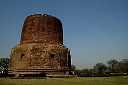  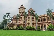 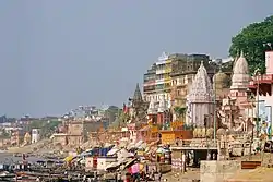 Clockwise from top-left: Kashi Vishwanath Temple, Dhamek Stupa at Sarnath, Dept of Electrical Engineering at IIT-BHU, Ahilyabai Ghat, Ramnagar Fort | |
 Location of Varanasi district in Uttar Pradesh | |
| Coordinates (Varanasi): 25°20′N 83°00′E | |
| Country |  India India |
| State | Uttar Pradesh |
| Division | Varanasi |
| Headquarters | Varanasi |
| Government | |
| • District Magistrate | S. Rajalingam, IAS |
| • Police Commissioner | Mutha Ashok Jain, IPS |
| • Mayor | Ashok Tiwari, BJP |
| • Lok Sabha constituencies | Varanasi |
| • Member of Parliament, Lok Sabha | Narendra Modi (Prime Minister of India) |
| Area | |
| • Total | 1,535 km2 (593 sq mi) |
| Population (2011) | |
| • Total | 3,676,841[1] |
| • Estimate (2021) | 4,110,000 |
| • Urban | 1,597,051 (43.4%)[2] |
| • Rural | 2,079,790 (56.6%)[2] |
| Demographics | |
| • Literacy | 78.41% |
| • Sex ratio | 913 |
| Language | |
| • Official | Hindi |
| • Additional Official | Urdu |
| • Regional | Bhojpuri |
| Time zone | UTC+05:30 (IST) |
| Vehicle registration | UP-65 |
| Website | Official Website |
It is surrounded by Mirzapur district, Jaunpur district, Ghazipur district, Chandauli district, and Bhadohi district. The Ganga (Ganges) river flows through the district. Part of the Varanasi division, the district occupies an area of 1,535 square kilometres (593 sq mi) and as of the 2011 Census of India, it had a population of 3,676,841.
Demographics
| Year | Pop. | ±% p.a. |
|---|---|---|
| 1853 | 420,822 | — |
| 1865 | 453,414 | +0.62% |
| 1872 | 502,185 | +1.47% |
| 1881 | 554,690 | +1.11% |
| 1891 | 628,380 | +1.26% |
| 1901 | 681,858 | +0.82% |
| 1911 | 685,391 | +0.05% |
| 1921 | 696,188 | +0.16% |
| 1931 | 745,318 | +0.68% |
| 1941 | 884,210 | +1.72% |
| 1951 | 1,047,522 | +1.71% |
| 1961 | 1,241,210 | +1.71% |
| 1971 | 1,514,420 | +2.01% |
| 1981 | 1,919,746 | +2.40% |
| 1991 | 2,508,110 | +2.71% |
| 2001 | 3,138,671 | +2.27% |
| 2011 | 3,676,841 | +1.60% |
| source:[3] | ||
According to the 2011 census, Varanasi district has a population of 3,676,841,[1] This gives it a ranking of 75th in India (out of a total of 640).[1] The district has a population density of 2,399 inhabitants per square kilometre (6,210/sq mi).[1] Its population growth rate over the decade 2001-2011 was 17.32%.[1] Varanasi has a sex ratio of 909 females for every 1000 males,[1] and a literacy rate of 77.05%. Scheduled Castes and Scheduled Tribes made up 13.24% and 0.78% of the population respectively.[1]
Administrative divisions
The district is made up of three tehsils: Varanasi, Pindra,and Rajatalab,[6] and eight Vidhan Sabha (Legislative Assembly) constituencies: Pindra, Shivpur, Rohaniya, Varanasi North, Varanasi South, Varanasi Cantt., Sevapuri, and Ajagara.
Education
Colleges/Institutes
- Indian Institute of Technology (BHU)[7]
- International Rice Research Institute[8]
- National Institute of Fashion Technology (Rae Bareli Extension)[9]
- National School of Drama[10]
- Sunbeam College for Women[11]
- Institute of Medical Sciences - BHU
- Indian Institute of Vegetable Research[12]
- Kashi Institute of Technology (KIT)
- National Seed Research and Training Centre[13]
- Uday Pratap College[14]
References
- "District Census Handbook: Varanasi" (PDF). censusindia.gov.in. Registrar General and Census Commissioner of India. 2011.
- "Demography"./
- Decadal Variation In Population Since 1901
- "Table C-01 Population by Religion: Uttar Pradesh". censusindia.gov.in. Registrar General and Census Commissioner of India. 2011.
- "Table C-16 Population by Mother Tongue: Uttar Pradesh". www.censusindia.gov.in. Registrar General and Census Commissioner of India.
- "Rajatalab tehsil inaugurated". The Times of India. Retrieved 23 July 2017.
- "Indian Institute of Technology(BHU)". www.iitbhu.ac.in. Retrieved 13 May 2021.
- "IRRI South Asia Regional Centre". 21 January 2019.
- "Designer Pool".
- "Varanasi Centre".
- "Sunbeam".
- "Institutions".
- "NATIONAL SEED RESEARCH AND TRAINING CENTRE VARANASI".
- "Udai Pratap Autonomous College: Accredited B Grade by NAAC :: Affiliated to Mahatma Gandhi Kashi Vidyapeeth, VarnasiA College With Potential for Excellence, DST-FIST & DBT-STAR College". www.upcollege.org. Retrieved 13 May 2021.
- "Home". bhu.ac.in.
External links

| History |
| ||||||||||||||||||||||||
|---|---|---|---|---|---|---|---|---|---|---|---|---|---|---|---|---|---|---|---|---|---|---|---|---|---|
| Administrative division | |||||||||||||||||||||||||
| Languages & dialects spoken |
| ||||||||||||||||||||||||
| Political representation |
| ||||||||||||||||||||||||
| Constituency |
| ||||||||||||||||||||||||
| Transportation |
| ||||||||||||||||||||||||
| Education |
| ||||||||||||||||||||||||
| Places of worship |
| ||||||||||||||||||||||||
| Ghats | |||||||||||||||||||||||||
| Point of interest | |||||||||||||||||||||||||
| Hospitals | |||||||||||||||||||||||||

| Topics | |
|---|---|
| Administration | |
| Regions |
|
| Divisions | |
| Districts |
|
| Major cities | |
| Villages |
|
.png.webp)