Clouère
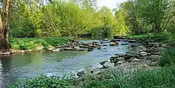
The Clouère (French: la Clouère, IPA: [la kluɛʁ]) is a river that flows 76.3 km (47.4 mi) through the west-central French departments of Charente and Vienne.[1] Its source is at Lessac, from which it flows generally northwest. It is a right tributary of the Clain, into which it flows between Château-Larcher and Aslonnes.
| Clouère | |
|---|---|
 | |
   | |
| Location | |
| Country | France |
| Physical characteristics | |
| Source | |
| • location | Lessac |
| • coordinates | 46°04′32″N 00°37′59″E |
| • elevation | 210 m (690 ft) |
| Mouth | |
• location | Clain |
• coordinates | 46°26′18″N 00°17′09″E |
• elevation | 85 m (279 ft) |
| Length | 76.3 km (47.4 mi) |
| Basin size | 382 km2 (147 sq mi) |
| Discharge | |
| • average | 2.55 m3/s (90 cu ft/s) |
| Basin features | |
| Progression | Clain→ Vienne→ Loire→ Atlantic Ocean |
Communes
Th Clouère flows through these communes, listed from source to mouth:
- Charente: Lessac
- Vienne: Availles-Limouzine, Pressac, Saint-Martin-l'Ars, Usson-du-Poitou, Saint-Secondin, Brion, Saint-Maurice-la-Clouère, Gençay, Marnay, Château-Larcher, Aslonnes
This article is issued from Wikipedia. The text is licensed under Creative Commons - Attribution - Sharealike. Additional terms may apply for the media files.