Crowdecote
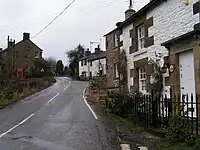
Crowdecote (sometimes spelled Crowdicote) is a small village in Derbyshire, England.[1][2] It is situated on the border between Derbyshire and Staffordshire about 6 miles (9.7 km) south of Buxton. Crowdecote is within the civil parish of Hartington Middle Quarter. It is thought that the name Crowdecote derives from Cruda’s Cot (Cruda was a Saxon landowner while 'cot' meant a form of shelter). Crowdecote is popular with walkers and ramblers because of its proximity to Chrome Hill, High Wheeldon and Parkhouse Hill to the north and Dovedale to the south.
| Crowdecote | |
|---|---|
 | |
 Crowdecote Location within Derbyshire | |
| OS grid reference | SK100651 |
| Civil parish | |
| District | |
| Shire county | |
| Region | |
| Country | England |
| Sovereign state | United Kingdom |
| Post town | BUXTON |
| Postcode district | SK17 |
| Police | Derbyshire |
| Fire | Derbyshire |
| Ambulance | East Midlands |
References
- Ordnance Survey: Landranger map sheet 119 Buxton & Matlock (Chesterfield, Bakewell & Dove Dale) (Map). Ordnance Survey. 2012. ISBN 9780319231890.
- "Ordnance Survey: 1:50,000 Scale Gazetteer" (csv (download)). www.ordnancesurvey.co.uk. Ordnance Survey. 1 January 2016. Retrieved 18 February 2016.
This article is issued from Wikipedia. The text is licensed under Creative Commons - Attribution - Sharealike. Additional terms may apply for the media files.