Desna (Guslitsa)
The Desna (Russian: Десна) is a river in Moscow Oblast, Russia. It is a left tributary of the Guslitsa (Nerskaya's tributary). It is 17 kilometres (11 mi) long, and has a drainage basin of 81 square kilometres (31 sq mi).[1] The Desna River freezes up in November–December and stays under the ice until April.
| Desna | |
|---|---|
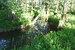 Desna River near the village of Chichevo | |
| Native name | Десна (Russian) |
| Location | |
| Country | Russia |
| Physical characteristics | |
| Mouth | Guslitsa |
• coordinates | 55°29′13″N 38°55′24″E |
| Length | 17 km (11 mi) |
| Basin size | 81 km2 (31 sq mi) |
| Basin features | |
| Progression | Guslitsa→ Nerskaya→ Moskva→ Oka→ Volga→ Caspian Sea |
Source of the river is in the Voskresensky District near the meeting point of the borders of three districts of the Moscow Oblast Voskresensky, Yegoryevsky and Orekhovo-Zuyevsky. Flows all over North, Desna running into Guslitsa about the village of Tsaplyno.
The Orekhovo-Zuyevsky District's villages: Mosyagino, Chichevo, Baryshevo, Kostenevo, Bezzubovo, Yuryatino are situated on the Desna.
In the higher and middle parts of the stream it has almost entirely lost its forest cover: upstream — because of the extraction of phosphorites, in the middle part — because of the plowing.

Sources
- «Река ДЕСНА», Russian State Water Registry
- Russian: Vagner B. B. Rivers and Lakes of the Moscow Area. — М.:Veche, 2007, — p. 92. ISBN 5-9533-1885-5.
- Russian: Moscow Oblast. Detailed Atlas. M 1:200 000. — М.:Eksmo, 2008, — p. 40. ISBN 978-5-699-26348-6.