Hochstollen
The Hochstollen is a mountain of the Urner Alps, located between the Klein Melchtal and the Melchtal in the canton of Obwalden. The border with the canton of Bern runs south of the summit.
| Hochstollen | |
|---|---|
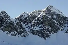 The east face | |
| Highest point | |
| Elevation | 2,481 m (8,140 ft) |
| Prominence | 160 m (520 ft)[1] |
| Parent peak | Glogghüs |
| Coordinates | 46°46′25″N 8°14′16″E |
| Geography | |
 Hochstollen Location in Switzerland | |
| Location | Obwalden, Switzerland |
| Parent range | Urner Alps |
The closest locality is Melchsee-Frutt on its east side.
References
- Retrieved from the Swisstopo topographic maps. The key col is the Wit Ris (2,321 m).
This article is issued from Wikipedia. The text is licensed under Creative Commons - Attribution - Sharealike. Additional terms may apply for the media files.