Lower Two Medicine Lake
Lower Two Medicine Lake is located partly in Glacier National Park as well as on the Blackfeet Indian Reservation, in the U. S. state of Montana.
| Lower Two Medicine Lake | |
|---|---|
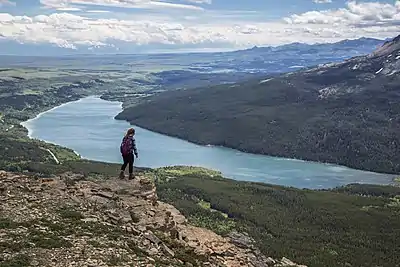
 Lower Two Medicine Lake with Scenic Point (centered) and Rising Wolf Mountain (right) | |
 Lower Two Medicine Lake  Lower Two Medicine Lake | |
| Location | Glacier National Park, Glacier County, Montana, US |
| Coordinates | 48°29′32″N 113°15′49″W[1] |
| Type | Natural/Dam |
| Primary inflows | Two Medicine Creek |
| Primary outflows | Two Medicine River |
| Basin countries | United States |
| Max. length | 2 miles (3.2 km) |
| Max. width | 0.40 miles (0.64 km) |
| Surface elevation | 4,882 ft (1,488 m) |
The lake is natural but has a small dam which regulates the lake level and reduces the potential for downstream flooding.[2] Lower Two Medicine Dam is an earthen structure built in 1967 for flood control and irrigation storage, impounding a maximum capacity of 25,120 acre-feet. The dam and reservoir are owned and operated by the Bureau of Indian Affairs.[3]
Because the lake lies partially on the Blackfeet Indian Reservation, a permit is necessary to fish in the eastern half of the lake.
References
- "Lower Two Medicine Lake". Geographic Names Information System. United States Geological Survey, United States Department of the Interior. Retrieved 2010-12-26.
- "Kiowa, MT" (Map (USGS Quad)). TopoQuest. Retrieved 2010-12-26.
- "Lower Two Medicine Lake". Archived from the original on 2012-11-06. Retrieved 2012-08-13.
This article is issued from Wikipedia. The text is licensed under Creative Commons - Attribution - Sharealike. Additional terms may apply for the media files.