Andagua District
Andagua District is one of fourteen districts of the province Castilla in Peru.[1]
Andagua
Antawa | |
|---|---|
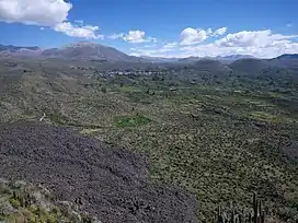 The "Valley of the Volcanoes" as seen from Antaymarka, looking north-west: the volcano T'iksu (on the left), Yana Mawras (on the right) and the village Andagua (Antawa) in the center | |
| Country |  Peru Peru |
| Region | Arequipa |
| Province | Castilla |
| Capital | Andagua |
| Government | |
| • Mayor | Santiago Juan Aguilar Herrera |
| Area | |
| • Total | 480.74 km2 (185.61 sq mi) |
| Elevation | 3,587 m (11,768 ft) |
| Population | |
| • Total | 1,251 |
| • Density | 2.6/km2 (6.7/sq mi) |
| Time zone | UTC-5 (PET) |
| UBIGEO | 040402 |
Geography
Some of the highest mountains of the district are listed below:[2]
|
|
References

Wikivoyage has a travel guide for Andagua.
- (in Spanish) Instituto Nacional de Estadística e Informática. Banco de Información Distrital Archived April 23, 2008, at the Wayback Machine. Retrieved April 11, 2008.
- escale.minedu.gob.pe - UGEL maps of the Caylloma Province 1 and 2 (Arequipa Region)
.svg.png.webp)
This article is issued from Wikipedia. The text is licensed under Creative Commons - Attribution - Sharealike. Additional terms may apply for the media files.