Hop Pole
Hop Pole is a hamlet in the South Holland district of Lincolnshire, England. It is situated between Deeping St James and Deeping St Nicholas, and on the A1175 Littleworth Drove road.
| Hop Pole | |
|---|---|
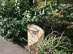 Victorian cast-iron milepost by Littleworth Drove | |
 Hop Pole Location within Lincolnshire | |
| Population | 105 |
| OS grid reference | TF186140 |
| • London | 80 mi (130 km) S |
| Civil parish | |
| District | |
| Shire county | |
| Region | |
| Country | England |
| Sovereign state | United Kingdom |
| Post town | SPALDING |
| Postcode district | PE11 |
| Dialling code | 01775 63 |
| Police | Lincolnshire |
| Fire | Lincolnshire |
| Ambulance | East Midlands |
| UK Parliament | |
No separate population statistic is available for Hop Pole. The best available report is for the whole Deeping St Nicholas civil parish with a total of 1323 people within 505 dwellings.[1] There are approximately 40 homes in Hop Pole, around 105 people pro-rata.
Hop Pole falls within the drainage area of the Welland and Deepings Internal Drainage Board.[2] Hop Pole had three pubs: The Oat Sheaf Inn (closed 1957 and since demolished), The Blue Bell Inn (closed 2012 and now a motorhome stop-over site) and the Hop Pole Inn (closed in 1928 following the death of its long-serving landlord, Charles Stainsby).

External links
 Media related to Hop Pole at Wikimedia Commons