Neede
Neede is a former municipality and a town in the eastern Netherlands.
Neede | |
|---|---|
Town | |
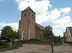 Neede church | |
 Flag  Coat of arms | |
 Neede Location in the province of Gelderland  Neede Neede (Netherlands) | |
| Coordinates: 52°7′59″N 6°36′50″E | |
| Country | Netherlands |
| Province | Gelderland |
| Municipality | Berkelland |
| Area | |
| • Total | 46.26 km2 (17.86 sq mi) |
| Elevation | 19 m (62 ft) |
| Population (2021)[1] | |
| • Total | 10,380 |
| • Density | 220/km2 (580/sq mi) |
| Time zone | UTC+1 (CET) |
| • Summer (DST) | UTC+2 (CEST) |
| Postal code | 7161[1] |
| Dialing code | 0545 |
On 1 January 2005 the municipality of Neede merged with the municipalities of Eibergen, Borculo and Ruurlo into the municipality of Berkelland.[3]
History
It was first mentioned between 1164 and 1176 as "de Nede", and means "the low-lying".[4] It developed on the southern flank of a hill along the Deventer to Vreden road. De Kamp is former havezate was built in 1636 for Otto Gansneb. It was redesigned in 1789.[5] In 1840, Neede was home to 864 people.[3]
Former population centres
Achterveld, Broeke, Hoonte, Lochuizen, Neede, Noordijk, Noordijkerveld and Rietmolen.
Gallery
 House in Neede
 Villa "De Bleeken Esch"
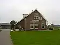 Former train station Kisveld
 Havezate Kamp
References
- "Kerncijfers wijken en buurten 2021". Central Bureau of Statistics. Retrieved 20 March 2022.
- "Postcodetool for 7161AA". Actueel Hoogtebestand Nederland (in Dutch). Het Waterschapshuis. Retrieved 20 March 2022.
- "Neede". Plaatsengids (in Dutch). Retrieved 20 March 2022.
- "Neede - (geografische naam)". Etymologiebank (in Dutch). Retrieved 20 March 2022.
- Ronald Stenvert & Sabine Broekhoven (2000). "Neeede" (in Dutch). Zwolle: Waanders. p. 234. ISBN 90 400 9406 3. Retrieved 20 March 2022.
This article is issued from Wikipedia. The text is licensed under Creative Commons - Attribution - Sharealike. Additional terms may apply for the media files.