Oirase River
The Oirase River (奥入瀬川, Oirase-gawa) is a river located in eastern Aomori Prefecture, in the Tōhoku region of northern Japan. The Oirase River is the only river that drains Lake Towada, a large caldera lake that lies on the border of Aomori and Akita Prefectures. The river flows in a generally eastern direction, through the municipalities of Towada, Rokunohe, Oirase, and Hachinohe before exiting into the Pacific Ocean. The upper reaches of the river form a scenic gorge with numerous rapids and waterfalls, and is one of the major tourist attractions of the Towada-Hachimantai National Park. The lower reaches of the river are used extensively for irrigation.
| Oirase River | |
|---|---|
 Oirase River gorge | |
 Location of the mouth in Japan  Oirase River (Japan) | |
| Native name | 奥入瀬川 (Japanese) |
| Physical characteristics | |
| Source | Lake Towada |
| • location | Aomori & Akita Prefectures, Japan |
| • coordinates | 40°28′N 140°52′E |
| • elevation | 401 m (1,316 ft) |
| Mouth | Hachinohe |
• location | Pacific Ocean |
• coordinates | 40°36′28″N 141°27′40″E |
• elevation | 0 m (0 ft) |
| Length | 67 km (42 mi) |
| Basin size | 820 km2 (320 sq mi) |
In 1996 the sound of flowing water at the Oirase River was selected by the Ministry of the Environment as one of the 100 Soundscapes of Japan.[1]
Gallery
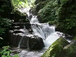
 Chōshi Falls
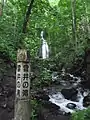 Kumoi Falls
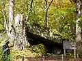 Rock cave at Oirase River
.jpg.webp) Oirase River
Oirase River
References
- Campbell, Allen; Nobel, David S (1993). Japan: An Illustrated Encyclopedia. Kodansha. p. 1134. ISBN 406205938X.
External links
Notes
- "残したい"日本の音風景100選"パンフレット" (PDF). Ministry of the Environment. Retrieved 18 February 2017.
| |||||||||||||||
| |||||||||||||||
| |||||||||||||||
| |||||||||||||||
| |||||||||||||||