Prievaly
Prievaly (Hungarian: Sándorfa) is a village and municipality in Senica District in the Trnava Region of western Slovakia.
Prievaly | |
|---|---|
Village | |
 Saint Michael's church, Prievaly | |
 Flag  Coat of arms | |
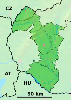 Prievaly Location of Prievaly in the Trnava Region  Prievaly Prievaly (Slovakia) | |
| Coordinates: 48°34′N 17°21′E | |
| Country | Slovakia |
| Region | Trnava |
| District | Senica |
| First mentioned | 1439 |
| Area | |
| • Total | 14.98[1] km2 (5.78[1] sq mi) |
| Elevation | 245[2] m (804[2] ft) |
| Population (2021) | |
| • Total | 973[3] |
| Postal code | 906 34[2] |
| Area code | +421 34[2] |
| Car plate | SE |
| Website | www.prievaly.sk |
History
In historical records the village was first mentioned in 1439.
Geography
The municipality lies at an altitude of 250 metres and covers an area of 15.007 km2. It has a population of about 906 people.
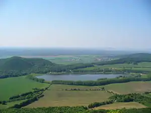
Prievaly as seen from Ostrý Kameň Castle with Buková reservoir in the foreground
References
- "Hustota obyvateľstva - obce [om7014rr_ukaz: Rozloha (Štvorcový meter)]". www.statistics.sk (in Slovak). Statistical Office of the Slovak Republic. 2022-03-31. Retrieved 2022-03-31.
- "Základná charakteristika". www.statistics.sk (in Slovak). Statistical Office of the Slovak Republic. 2015-04-17. Retrieved 2022-03-31.
- "Počet obyvateľov podľa pohlavia - obce (ročne)". www.statistics.sk (in Slovak). Statistical Office of the Slovak Republic. 2022-03-31. Retrieved 2022-03-31.
This article is issued from Wikipedia. The text is licensed under Creative Commons - Attribution - Sharealike. Additional terms may apply for the media files.