Troughton Rocks
Troughton Rocks (Bulgarian: скали Трутън, romanized: skali Troughton, IPA: [skɐˈli ˈtrutən]) are the group of rocks off the northwest extremity of Snow Island in the South Shetland Islands, Antarctica lying in an aquatory of 27 ha that is 315 m long in east-west direction and 120 m wide. The vicinity was visited by early 19th century sealers.[1]
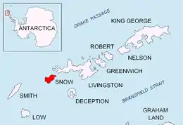 Location of Snow Island in the South Shetland Islands | |
 Troughton Rocks Location of Troughton Rocks  Troughton Rocks Troughton Rocks (South Shetland Islands) | |
| Geography | |
|---|---|
| Location | Antarctica |
| Coordinates | 62°44′42″S 61°33′23″W |
| Archipelago | South Shetland Islands |
| Area | 27 ha (67 acres) |
| Length | 315 m (1033 ft) |
| Width | 120 m (390 ft) |
| Administration | |
| Administered under the Antarctic Treaty | |
| Demographics | |
| Population | uninhabited |

The feature is named after Edward Troughton (1753-1835), a British instrument maker who improved the theodolite design; in association with other names in the area deriving from the early development or use of geodetic instruments and methods.
Location
Troughton Rocks are centred at 62°44′42″S 61°33′23″W,[2] which is 2.7 km west-northwest of Byewater Point. British mapping in 1968.
Maps
- South Shetland Islands. Scale 1:200000 topographic map. DOS 610 Sheet W 62 60. Tolworth, UK, 1968
- L. Ivanov. Antarctica: Livingston Island and Greenwich, Robert, Snow and Smith Islands. Scale 1:120000 topographic map. Troyan: Manfred Wörner Foundation, 2010. ISBN 978-954-92032-9-5 (First edition 2009. ISBN 978-954-92032-6-4)
- Antarctic Digital Database (ADD). Scale 1:250000 topographic map of Antarctica. Scientific Committee on Antarctic Research (SCAR). Since 1993, regularly upgraded and updated
Notes
- L. Ivanov. General Geography and History of Livingston Island. In: Bulgarian Antarctic Research: A Synthesis. Eds. C. Pimpirev and N. Chipev. Sofia: St. Kliment Ohridski University Press, 2015. pp. 17–28
- Bulgarian Antarctic Gazetteer. Antarctic Place-names Commission
References
- Bulgarian Antarctic Gazetteer. Antarctic Place-names Commission. (details in Bulgarian, basic data in English)
External links
- Troughton Rocks. Adjusted Copernix satellite image
This article includes information from the Antarctic Place-names Commission of Bulgaria which is used with permission.