Calacuccia
Calacuccia (French pronunciation: [kalakutʃ(j)a]) is a commune in the Haute-Corse department of France on the island of Corsica. It contains the Lac de Calacuccia, a hydroelectric reservoir, just south of the village of Calacuccia.
Calacuccia | |
|---|---|
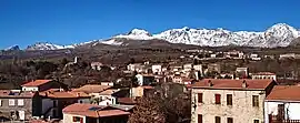 A panorama of Calacuccia | |
Location of Calacuccia | |
 Calacuccia  Calacuccia | |
| Coordinates: 42°20′12″N 9°01′05″E | |
| Country | France |
| Region | Corsica |
| Department | Haute-Corse |
| Arrondissement | Corte |
| Canton | Golo-Morosaglia |
| Government | |
| • Mayor (2021–2026) | Mathieu Acquaviva[1] |
| Area 1 | 18.77 km2 (7.25 sq mi) |
| Population | 268 |
| • Density | 14/km2 (37/sq mi) |
| Time zone | UTC+01:00 (CET) |
| • Summer (DST) | UTC+02:00 (CEST) |
| INSEE/Postal code | 2B047 /20224 |
| Elevation | 705–1,760 m (2,313–5,774 ft) (avg. 847 m or 2,779 ft) |
| 1 French Land Register data, which excludes lakes, ponds, glaciers > 1 km2 (0.386 sq mi or 247 acres) and river estuaries. | |
Geography
Climate
Calacuccia has a warm-summer mediterranean climate (Köppen climate classification Csb). The average annual temperature in Calacuccia is 11.5 °C (52.7 °F). The average annual rainfall is 891.5 mm (35.10 in) with November as the wettest month. The temperatures are highest on average in July, at around 21.3 °C (70.3 °F), and lowest in January, at around 3.6 °C (38.5 °F). The highest temperature ever recorded in Calacuccia was 40.0 °C (104.0 °F) on 23 July 1983; the coldest temperature ever recorded was −14.6 °C (5.7 °F) on 11 February 2012.
| Climate data for Calacuccia (1981–2010 averages, extremes 1950−2016) | |||||||||||||
|---|---|---|---|---|---|---|---|---|---|---|---|---|---|
| Month | Jan | Feb | Mar | Apr | May | Jun | Jul | Aug | Sep | Oct | Nov | Dec | Year |
| Record high °C (°F) | 21.4 (70.5) |
19.8 (67.6) |
27.0 (80.6) |
28.0 (82.4) |
32.9 (91.2) |
36.4 (97.5) |
40.0 (104.0) |
37.5 (99.5) |
35.0 (95.0) |
30.0 (86.0) |
23.2 (73.8) |
19.0 (66.2) |
40.0 (104.0) |
| Average high °C (°F) | 8.5 (47.3) |
9.2 (48.6) |
12.3 (54.1) |
14.6 (58.3) |
19.9 (67.8) |
24.7 (76.5) |
28.8 (83.8) |
28.2 (82.8) |
23.0 (73.4) |
18.3 (64.9) |
12.4 (54.3) |
9.1 (48.4) |
17.5 (63.5) |
| Daily mean °C (°F) | 3.6 (38.5) |
3.9 (39.0) |
6.7 (44.1) |
9.0 (48.2) |
13.6 (56.5) |
17.9 (64.2) |
21.3 (70.3) |
20.6 (69.1) |
16.1 (61.0) |
12.3 (54.1) |
7.4 (45.3) |
4.7 (40.5) |
11.5 (52.7) |
| Average low °C (°F) | −1.3 (29.7) |
−1.4 (29.5) |
1.1 (34.0) |
3.3 (37.9) |
7.2 (45.0) |
11.0 (51.8) |
13.8 (56.8) |
13.0 (55.4) |
9.3 (48.7) |
6.4 (43.5) |
2.5 (36.5) |
0.2 (32.4) |
5.5 (41.9) |
| Record low °C (°F) | −12.0 (10.4) |
−14.6 (5.7) |
−13.4 (7.9) |
−7.0 (19.4) |
−3.5 (25.7) |
1.1 (34.0) |
1.0 (33.8) |
2.0 (35.6) |
−2.0 (28.4) |
−3.2 (26.2) |
−8.2 (17.2) |
−10.5 (13.1) |
−14.6 (5.7) |
| Average precipitation mm (inches) | 77.9 (3.07) |
73.9 (2.91) |
70.7 (2.78) |
87.9 (3.46) |
61.0 (2.40) |
35.4 (1.39) |
15.6 (0.61) |
29.9 (1.18) |
62.0 (2.44) |
118.4 (4.66) |
129.8 (5.11) |
129.0 (5.08) |
891.5 (35.10) |
| Average precipitation days (≥ 1.0 mm) | 8.1 | 8.1 | 8.1 | 10.0 | 6.5 | 4.0 | 2.2 | 3.9 | 6.1 | 8.5 | 10.4 | 10.2 | 86.0 |
| Source: Meteociel[3] | |||||||||||||
Population
| Year | Pop. | ±% |
|---|---|---|
| 1962 | 518 | — |
| 1968 | 556 | +7.3% |
| 1975 | 507 | −8.8% |
| 1982 | 418 | −17.6% |
| 1990 | 331 | −20.8% |
| 1999 | 340 | +2.7% |
| 2008 | 325 | −4.4% |
References
- "Répertoire national des élus: les maires". data.gouv.fr, Plateforme ouverte des données publiques françaises (in French). 9 August 2021.
- "Populations légales 2020". The National Institute of Statistics and Economic Studies. 29 December 2022.
- "Normales et records pour Calacuccia (2B)". Meteociel. Retrieved 10 June 2022.